Although the same route/direction as last year, I have posted this trip report by way of a contrast to the remarkably fine weather conditions in the south west around the 13th Sep 07 & secondly after reading a note or two on the subject of 'open passages' recently that suggested this route is generaly regarded as an excellent introduction to passages with slightly more exposure than the usual trips around our coastline. The long slog of open passages along with the need very often for hard paddling at least at some stage is not the want of every kayaker, but here again is an honest description aimed at those who may be tempted, & I recommend this route. --------------------------------------------- Taking part: Colin Appleby & Mike J.Smith. Weeks of unsettled weather & a period of illness suggested the best course of action would be to cancel my leave & wait for more suitable conditions in order to do the reverse of last years route [posted on SESK:- Isles of Scilly to Longships 13th Sep. 07] Sennen Cove to Great Ganilly island/ Isles of Scilly was the plan for Sep. 8th & arranged some months ago with Colin who was keen to do the route while he was over here from France. My aim was to do my solo thing well in advance & then join Colin for a second outing, but thanks to the weather I couldn't fit it in. The original plan for was for 3 in the group & we were disapointed when Mark Sky had to pull out due to employment commitments & for a while it looked like I would be too to unwell to do the route leaving Colin with a solo trip in conditions, as it turned out, that may have been considered unsuitable. Leading up to the 8th Sep. the weather was pretty awful but always the poss. of a 'window' at some stage that would suite us but it meant being on hand to go at short notice, & with that in mind Colin & I headed off to Penzance shortly after we noticed a possibility due within a day or so. Wind direction & strength was all in favour of the route out from the Scilly's, not our intended direction but at least something. We of course arrived in Penzance with conditions ideal for our prefered route out to the Scilly's......it happens that way sometimes, too late for that & no other choice than to take the ferry out to the islands & do the alternative route in the forecast window if & when it appeared. At St Mary's with plenty of beach to load the boats & with protection from the wind, we launched with a bright sky to the north & headed out past the quay hopeful of a pleasant but breezy trip out to the Eastern Islands, but once clear of the harbour in open water the sun went home behind a very dark sky & the wind velocity increased. Overnight protection from the weather was the main priority, & with the wind speed still increasing from nnw we agreed to to go over to Tresco as a first option & while ashore view the sea conditions towards the north from the high ground up from the beach. From what we could see it looked reasonable & with the wind dropping we continued on to the outer isalnds to the east in order to check the beach conditions on Great Ganilly. Colin spotted a section of beach earlier with good protection for the night at the top of the beach, so after a trip around Great Ganilly island we went back to Great Arthur island & went ashore for the night. Through the night we monitored the wind speed & direction for any pattern, trusting in the forecast for an eventual westerly by the early hours, but my devise indicated a mainly north wind with at best 30 degrees in our favour & way above the 10n in the met office report. We let the early morning launch time time go by & agreed to wait-out the day for favourable conditions with the evening tide. By 3pm it looked promising, the night before hinted of a red sky, & as it prooved the day was bright, sun & a few white clouds but 15n windspeeds gusting, but it was dropping so we made ready & headed out with the intention of being on the start line for 4.30pm. Ckecking sea conditions as we moved into more open water, nearing the line of departure between Gt Ganilly & Gt Arthur islands the wind speed dropped to just a few knot's. Having completed the route myself last year this was Colin's trip so to speak, to plan his route as he thought best, with just a couple of minor items of local knowledge I gained the year before. So as the start line went past & with his GPS running & set to log the route to the Longships light we continued on into deeper water, observing the surface swell out to the horizon, it looked ok, with no visible major white horses. Not entirely certain it was 'on', the wind dropped to no more than a breath......both very suspiciouse, Colin called out..."Are we going"...."Yep" came the reply & with skeg fully down to counter the quartering sea from port aft' we went on with a sea swell that was sustained throughout the trip, 2m peaking 3 with a few mildly breaking waves. Start time was 4.30pm & it took a further 500yds or so to confirm we were in deeper water & free of the shallow seabed profile of the land, & as it looked, fully exposed to the maximum sea conditions that unless the weather deteriorated, would probably remain that way for the passage to Sennen Cove. The aim was to get through as much of the shipping lanes as poss. before nightfall & the pace set by Colin was what was needed & I was pretty disapointed at not being able to meet it, a couple of weeks off from hard paddling would have seen me in far better shape after 6 weeks illness. The sky to port, star'bd & foreward was marked with a variety of weather systems, minor anvil clouds, higher winds at altitude & as Colin pointed out, clear sky's on the windward side over our shoulders. Sunset was due 6.30pm between Lat. 48 & 50 & we were in darkness as we aproached the eastern extreme of the south bound lane having observed about 5 commercial vessels up till then, all passing through ahead of us. Later, approaching the line of departure from the shipping lanes the vessel we observed at 2.5 miles going around Gwennap Head enroute to the separation zone, took the shortest course & passed astern of us at us at 800yds showing green all the way. A short time later the vessel steaming south ahead of us 500yds was a large commercial fishing vessel in the inshore traffic zone with workdeck illumunated & the regulation several sqaudrons of seabirds in attendance. During the run through these lanes my main light failed & my reserve 'C' light became caught-up in tag lines to other equipment....raffting I could have freed it but that meant wasting valuable time so I did the best I could by heaving it into the best position poss. & no option for cutting it loose in the sea conditions together with the poss. of seeing it go over the side. I made do but annoyingly Colin could not see my light all of the time. We were on target for the Longships light, well visible from berfore dusk, & the other good thing about this shipping hazard is it is located a mile out from Land's End.......an excellent reference point to course & position as it moves port or star'bd against the lights from the headlland behind while negotiating that section in the tidal sequence when it devides into 2 as it heads into Land's End. Colin's colour printout of the track/log indicate a couple of sharp course corrections he made which coinside with my view on the night of the Longships light moving to star'bd & then to port, we were in that thin line between the north & south running streams that can take you by suprise. The Longships light took ages to grow in height & when it did it seemed to happen all at once as we neared, passing the lighthouse a few hundred yds to our star'bd the outline of the rocks could be seen with the steady hum of the swell rolling through the shallows. Closer-in, the dip in the headland could be seen to the north of Land's End against a hint of light from buildings in Sennen Cove. Almost upon the final run-in to the cove, Colin, true to his GPS settings maintained his course in order to safely clear the land on the edge of Sennen Cove....safe now, & with local knowledge I steered a course closer-in & direct into the cove thinking at one stage I may have been a little bit bold when a larger than average one went smacking into the rocks over to my right. Nearing the lifeboat station it was time to relax, & a little later we both glided up the beach on a 1m surf on an illuminated secion up by the car park.....the "Yarhooo" over to my right indicated Colin enjoyed the coming ashore. It was a nice way to end the trip. Colin recorded speeds of 5.7n running with the swell & 1.3n in the troughs. My under par physical condition combined with the sea conditions added time to the schedule but other than that it was a great trip, good vis. a breath of a breeze all the way & a great landing in Sennen Cove: unlike last year, in wonderful conditions, I landed at the troublesome far end of the cove in order to be alone & sat in my kayak feeling satisfied when I should have got out & pulled my boat clear.....I didn't, & a large one sneaked up on me & sucked me back down the beach & knocked me out of my kayak. A local enquired if that was the usual way that kayakers came ashore, I said "no.. it's a warm evening & I've had a good hard paddle, thought I would cool-off a bit". As I mentioned, this was Colin's trip, with his enhanced GPS devise & tracking software installed on a PC back in France, it was a fine demonstration of available technology put to very good use....I'm lucky if I remember to include a basic GPS in my kit, but with the result of Colin's work, our passing through a difficult section of tidal stream which in poor vis. could be dodgy, I too could be persuaded to invest in a GPS that has the capacity to download chart software. ---------------------------------------------------------------- I knew Colin was coming over from France with his new boat, a Reval Viking, so I got one from Peter at Shoreham Seakayaks in time for the trip, so this was my first outing in the new boat, it incorporates a much faster hull design that I have encountered before, with just enough angle on the bow to provide excellent edging capabilities. With a generous skeg in the difficult sea conditions encountered, the Viking pointed beautifully at all times. Colin's was fitted with a rudder too & I know, like me, he is over the moon with this kayak. October ?.....we are all due some descent paddling weather, & with 2 weeks leave booked for a few days exped. I have written-into the arrangements the right to depart for Penzance at short notice to do the route out to the Scilly's......there's time yet, with luck.
Written by Mike Smith.
Friday, October 3, 2008
Thursday, October 2, 2008
St Lawrence to Maldon 14th September
I thoroughly enjoyed the trip on Sunday, even though this is local home waters to me. I rarely go so far up stream. I would normally launch further east with Osea island or the stone pub being as far upstream as I would go. Everybody arrived pretty much on the dot, as said above it was local (within 25 miles) for me, it was Johns turn to do the driving all the way from bucks this time. On arrival the slipway that I had intended to use was closed off with six ft metal gates and a hefty padlock. A quick word at the adjacent sailing club enabled the access to the beach via their slip. The sailing club were in the process of setting up a power boat / water-ski race day, something that I have never come across on the Blackwater before. I wasn’t disappointed that we were going in the opposite direction. The weather was good, slightly overcast but no rain, wind was slightly stronger than expected at a force three coming from the east which later picked up to a low four. The paddle out was quite a straight forward affair, with low following waves. Being local and enclosed water, I had only planned the route in the loosest of ways, out around the top of the islands and back around the bottom. As we came around Osea island, the route around the top of Northy island is far from obvious, being hidden amongst the far shore. We needed to adjust course slightly to the north. Just as well Rog knew were he was going, I continued to circumnavigate Osea. There were several dingy races going on from Heybridge basin sailing club and we had a short game of dodgems getting across the channel and over to Northy island. As we came into the quay at Maldon the visitors pontoon was only partly occupied and a lot further out of the water than I remembered it from my last visit, about three years ago. I clambered out only to be told that there was a Thames barge arriving on the soon to be high tide. Back into the boat and around to Maldon prom which forms part of the town park. A large traditional boat followed us into the quay which I noticed not to be of a local design.

A visit to Mr Google revealed it to be a 1980 build concrete hull replica, a bit like a big Caterham seven car. It’s a 70ft gaff rigged cutter, the originals being built in the late 19th and early 20th century, being used as fast dispatch vessels for the Royal Navy. We decided to forego a lunch time drink and instead set off for the return journey slightly early a short while before the turn of tide. Just to pick things up a little as we left the protection of Northy island, wind was now against the tide for the two mile trip to Osea. At Osea we took a second short break, while, with some amusement we watched as a yacht came dangerously close to shore while seemingly struggling to tack. He was either lucky or knew his home waters very well. For the last two and a bit miles we decided to take the choppy route down the middle of the main channel where the white bits were. This led to quite a fun paddle though 3 maybe occasionally 4 ft, short and steep bouncy waves with plenty of spray and buried front ends. At the end of the trip, Sitting on the sea wall outside the Stone pub, with pint in hand. The estuary is only about a mile and a half wide at this point, most of which is fairly shallow emptying out at low tide. This leaves a maybe 2or 3 hundred metre wide channel. It was quite interesting to see a classic case of wind against tide. In the shallower and slower moving areas there were a few waves but no broken water showing. Whereas the water ebbing quite strongly against the wind in the deep water channel looked (as we well knew) to be decidedly choppy with lots of white stuff. A good enjoyable paddle, again with good company. Thanks to all who came out. On a personal note I must remember to take more photos on these outings.
Approaching Maldon quay
Written by Peter Moyse
 The track.
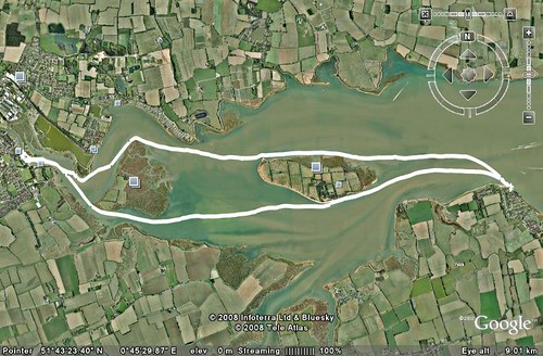
A visit to Mr Google revealed it to be a 1980 build concrete hull replica, a bit like a big Caterham seven car. It’s a 70ft gaff rigged cutter, the originals being built in the late 19th and early 20th century, being used as fast dispatch vessels for the Royal Navy. We decided to forego a lunch time drink and instead set off for the return journey slightly early a short while before the turn of tide. Just to pick things up a little as we left the protection of Northy island, wind was now against the tide for the two mile trip to Osea. At Osea we took a second short break, while, with some amusement we watched as a yacht came dangerously close to shore while seemingly struggling to tack. He was either lucky or knew his home waters very well. For the last two and a bit miles we decided to take the choppy route down the middle of the main channel where the white bits were. This led to quite a fun paddle though 3 maybe occasionally 4 ft, short and steep bouncy waves with plenty of spray and buried front ends. At the end of the trip, Sitting on the sea wall outside the Stone pub, with pint in hand. The estuary is only about a mile and a half wide at this point, most of which is fairly shallow emptying out at low tide. This leaves a maybe 2or 3 hundred metre wide channel. It was quite interesting to see a classic case of wind against tide. In the shallower and slower moving areas there were a few waves but no broken water showing. Whereas the water ebbing quite strongly against the wind in the deep water channel looked (as we well knew) to be decidedly choppy with lots of white stuff. A good enjoyable paddle, again with good company. Thanks to all who came out. On a personal note I must remember to take more photos on these outings.
Approaching Maldon quay
Written by Peter Moyse
The track.
Subscribe to:
Posts (Atom)