Tuesday, September 30, 2008

Weymouth to Lulworth Cove

Well that was a good one. Eight of us on this trip, I will not do a role call as I’m bound to get at least one name wrong. To paddle below the cliffs of the Jurassic Dorset coast at least once a year has to be a must do paddle for anybody in our region, I’m sure that a basic knowledge of geology would have made it all the more interesting. Following yet another long drive for a good number of us we met at Bowleaze Cove car-park, which purely by chance, turned out to be a popular launching site with at least one other group turning up at the same time. We finally got on the water, regulation thirty minutes late, just as well that there are no real tides to worry about along this stretch of coast The weather was exactly as forecast force two or less with a clear sky. This all led to one of those balmy relaxed paddles, taking in the sights along the base of the cliffs and stopping for plenty of photographs. It’s not until you take a reference point, such as gulls at the cliff top that it registers how high these cliffs are. We passed under the arch at Bats head and dodged the snorkels in Man-o War bay, before arriving at Durdel Door. Durdel Door always creeps up on me just appearing as a rocky outcrop until I’m right on top of it. On to Lulworth for a relaxed lunch, at the far quieter end of the cove. On the return trip, just as forecast, the wind rose slightly to a moderate three for a short period, giving rise to a few small waves just to keep us awake. We arrived back at the launch point at 4:30pm pretty much as expected. Once more thanks for the good company of all those that attended.

Written by Peter Moyse


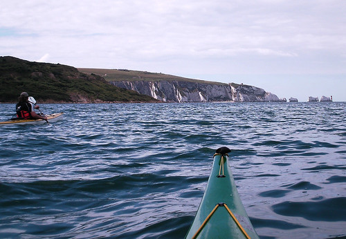
Below the chalk cliffs.


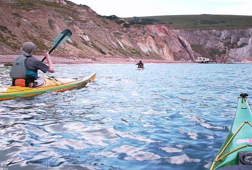
just to give it a bit of scale.

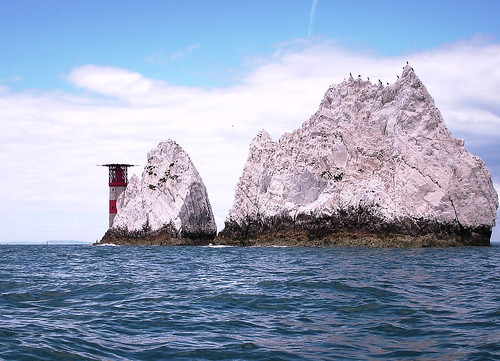
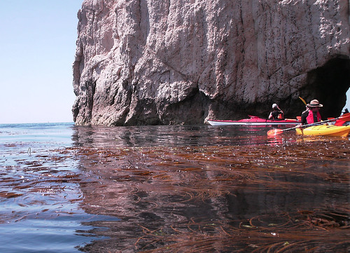
through the arch at Bats Head
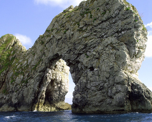
Durdle Door.

Friday, September 26, 2008

Milford-on-Sea and the Needles 13th July

Which became Lymington Harbour to the Needles,. Three paddlers on this trip, myself, (Gunner) Graham and Peter Hennessay. Once more an early start for the 150 mile drive to Lymington, this doe’s have the advantage of clear roads all the way and we arrived nearly half an hour early. Following a strong cup of coffee and a slightly greasy bacon and egg bap from a local cafĂ©, Graham and I met Peter at the planed location.
After my usual faffing around with bits of kit, we were on the water maybe ten minutes latter than planned, which in my book counts as on time

A straight forward paddle over to the island ensued, we remained just outside the deepwater channel coming out of Lynmouth and then took a heading of 190 degrees to pass close to fort Albert, before altering course to cross Totland bay. On the way over we keep a constant watch for other traffic but being at the quieter end of the Solent and still quite early, we generally had plenty of space. Considering that it was a neap tide and we were paddling into an admittedly very light breeze, when I looked down at my GPS I was surprised to see that we had clocked in excess of six and a half Knots. I can begin to see how it is possible to do the sixty-nine mile circumnavigation of the island in a single day. Having arrived at Alum bay early, we took a lunch break, while we waited for the slack tide, before going on the Needles. Not having paddled around the Needles before, two points took my attention. I’ve known, for some time that there is a military establishment on the cliff top, but was quite surprised to see, what I took to be gun emplacements, at close to water level. These could only have been tunnelled down to from above and cut from inside the cliff face. Secondly I was taken by how sharp the upper edge of the Needles stacks are. As the sun had now shown its face we briefly stopped back in Alum bay to shed a layer of clothing, before, making the crossing back to Lynmouth. We followed a very similar route to the journey out, but now that the tide had turned and the wind had built slightly, the tide race between Hurst spit and the island was flowing nicely, and the water was quite confused. At one point I had to call on my bracing for much more than a bit of extra support. Remembering this was a neap, I would be wary of crossing here on a spring tide. Once across the race and behind the spit the water settled down and with a good force three and the tide behind us we made good time back to Lynmouth.

All in a good trip, the weather was exactly as the forecast predicted although a little more sun would have been good. Again good company, and thanks
to those who came along. Below a few photos.

Crossing the Solant


Approaching Alum Bay


Around we go


And back to Lynmouth


Wednesday, September 24, 2008

Norfolk 29th June 2008

The plan was to meet at Burnham Overy at about 9:30am. Set up a shuttle and then paddle from Cley beach, back to Burnham Overy, via Blakney harbour and Wells. The weather forecast was for a light, south westerly force three or low force four wind, overcast sky with a small chance of showers late in the afternoon. One of the forecasts said rising force five after six pm. This meant that the wind would generally be of a light nature on our port bow quarter. The plan worked perfectly, except that in good SESK tradition things are never quite that straight forward. Through no fault of their own three people had to drop out at the last minute, so it was just Grazie and myself. After an early start we met at the allotted car park. Following some brief introductions and moving kit around we made our way to Cley beach. At Cley we duely paid our car park entry fee, which, I later didn’t feel so bad about, having noticed that it went toward the Norfolk Wild life trust, and the up keep of Blakney reserve. Off we set, with a gentle swell and the usual talk of boats and previous trips. The Turns were diving for food all around and we made good time to Blakney point. Approaching the shallows at the harbour entrance there was a noticeable surf rising up over the sand banks, so we continued to the buoyed deep water channel before turning into the natural harbour. We now came to the first highlight of the day, paddling through the seal colony. We seemed to have timed it quite well, with a rising tide, there were literally hundreds of seals grouped on to rapidly reducing sand banks. There appeared to be both common and grey seals ranging in colour from some substantial looking, almost black males, to young cubs that still retained the last of their white coats. Unfortunately due to technological failure, I have no photographs so we will have to make do with a down load.


Having then bumped into, and had a short chat, with a kayaking dog, who was accompanied by a couple of humans, we were swept by the tide around to the old lifeboat station. Here we stopped to explore. Picked our way over the muddy foreshore and visited the blue tin, lifeboat station now turned into a local museum. Back on the water the tide had risen enough for the trip boats to get out of Blakney quay, two passed us on the paddle back out of the harbour. As we paddled I looked around and noticed that Grazie had a large tail in the form of a seal following him within inches of his stern, others swam around and under us through quite clear and surprisingly warm water. And now the fun began. This is to be the longest leg of the trip being six and a half miles around low laying sandbanks to Wells beach. The wind was now increasing to a strong four possibly even climbing to a five. We had to stay off shore a bit, to avoid the surf and spray, which added to the distance. The waves built from a gentle swell to a two or three foot chop. As we paddled into the wind my GPS was reading two and a half miles an hour, not even knots. It was becoming evident that Grazie was the stronger paddler, as he was pulling ahead slightly. I still hadn’t fully recovered from having a cold for the previous two days. At least that’s my excuse and I’m sticking with it. I think that we were both quite pleased when we arrived at Wells beach for a latter than planed lunch break. Sitting on the beach it was quite a pleasant afternoon and the wind seemed to have dropped, even if it was a bit overcast. Last leg of the day a five and half mile gentle paddle along the beach, in the afternoon sun taking in the sights, or so I thought. It started off like that, then after about fifteen to twenty minutes, the head wind started to build, and kept building. A strong four, then a five. Did it stop there? No it kept building to a to a solid force six. It was partly coming off of the land so no great waves but lots of white caps and spray to keep us awake. Then the heavens opened. I would be hard pushed to call it rain, it was more just water pouring out of the sky. Visibility went down to less than a couple of hundred yards and my GPS was reading just over one mile an hour. After an hour or so of this getting nowhere rapidly. I had had enough and headed into the beach. I decided to trolley the last three or four hundred yards to Burnham creek, while Grazie continued to paddle just off shore. Having reached the creek, about twenty minutes latter, which must have been very hard to spot from the sea, being little more than water running over the beach. The wind had now dropped the rain had stopped and suddenly the sun shone. Due to the wind and the consequent slow pace, we were now considerably later than intended and the tide in the creek was outgoing at quite a pace. Some amusement was had trying to battle against the current, which led to some of the wrong sort of paddling taking place. Once we reached the first corner the flow dropped and a gentle paddle pursued for the last mile or so back to the car. All in, an interesting and memorable first SESK trip of 2008 and one that had everything. Lots of wild life, Seals, Terns I even spotted an Eget in the dying moments of the trip. Lots of weather from bright sun and surf to a howling gale and torrential rain. And by no means least good company.