This is my first time putting together a blog so please bear with me.
The trip was Burnham Overy Staithe (BOS) to Blakeney point and back. Time on the water paddling was planned for six hours.
We left BOS three hours before low water and followed the river through sand dune islands and out into to the sea. At the entrance to this inlet was a suggestion of what doing this could be like on a rough day as the out going tide caused eddies and breaking surf, small on this occasion over the sand banks, but with the ability I felt to catch the unaware out on another day. This was evident all along the ever growing sand banks as we past towards Wells next the sea. Peter also recounted the last time he past this way last year in force six conditions, and it sounded testing.
However for us we simple sped along assisted by the current and a light South Westerly, we arrived at Wells in good time and with little effort, and again the force of the emptying river could be seen on the channel markers as we flew past. There was not a cloud in the sky a light swell. I found myself drifting into a trance just the sound of paddle on water and a warm sun on your face, I found myself having to break out of it, having a little chat with Pete then back into it. One of those rare occasions when you are thinking about nothing, Car needing mot, gone, kitchen needs painting, gone, only had three hours sleep the night before as my little boy is growing teeth, well two out of three's not bad. there was a section when Blakeney did not get any closer for a while. Then with a little bit of unexpected surfing and being surrounded by the seals trying to put me off we where there.
We did try to keep a respectful distance by the seals wanted to come for a look, we then pulled up for lunch, more trance like state where I could have just sat on that sand bank until the tide came in. Peter though got a grip of me, and we headed back, much the same on the way back.
We got to the mouth of BOS, as we neared Skull Island, yes that is its name, and shiver me timbers thems land lubbers 'ave takens all the water. So not for the first time out came the tow line and we dragged our boats the last KM through shallow water and tidal lagoons amongst the sand dunes. I have to be honest I did enjoy this bit, it cooled me down, and I identified what a great place to bring my son back to. We pretty much came in on time, I had had one of the simplest and best trips of my sea kayaking life.
We finished with and ice cream and a not to bad drive home.
I will be back to the area and with my tent next time, as this would be a top place to overnight. Pete said in passing as we headed towards Blakeney would'nt it be nice just to keep going, I will hold that though. All the pictures for this can be found in the Gallery in Norfolk 2008.
Saturday, May 30, 2009
Thursday, May 21, 2009
Harwich to Pin Mill 12/04/09
HW Pin Mill 15.30
I started at Harwich Beach (public slip) at 13.00 approx. After 30 mins I had paddled across the deep water channel to Shotley Gate / Marina. On the way over a RHIB slowed so as not to catch me in it's wake. Very courteous I thought, but, at a second look I thought I recognised the local RNLI engineer. I pretended not to notice so as to avoid comments later in the day at my local. In the event it turned out to be someone else. I stopped at the beach adjunct to Shotley Marina to take off my cag, sup a quick coffee and call in an ETA. The thing about Shotley Beach is the view of the container ships. They are massive. I have a great desire not to be near them when they are under way or turning. Of course on this piece of water it is eyes everywhere for the various ferries that leave Parkeston Quay, a couple of miles into the Stour estuary, the ferry, the Alert (Survey), the fishing boats, the yachties and of course the ubiquitous gin palaces, who only seem to slow to the speed limit, 6knots, on the approach of sailing (or paddled) vessels.
Departing Shotley I had estimated 1 1/2 hours for the 8k paddle. The tide was running full and the onshore wind (Easterly) gave me good assistance. I kept inshore of the port channel marks all the way up the river easily keeping pace with the yachts resisting the use of their engines until all hope was lost to them.
About 3k into the river the mooring buoys started their long line up to Ipswich. A Thames barge had cruised past whilst I was on the beach at Shotley and with the pace I was making I felt sure I would see her again. Alas, she had gone. There is a race for these craft at least once a year in the Summer and they often lie at Pin Mill, but not today.
My route from Shotley was basically a dog leg and despite steep sand and stone beaches the Orwell has it's fair share of mud and sand banks, as is common with the Essex and Suffolk coast. I used the withies and older deepwater marks as my pointers and forgot the bearings I had taken as the weather improved and the sun shone. Vis. was a little hazy but it seems to have been like that for a few weeks now. I take a look over Pennyhole Bay usually twice a day and even the tower at Walton on the Naze has been obscurred more often than not , both morning and evening.
So I aimed at the point keeping No2 and Collimer on the starboard side. Rounding the headland the Orwell Bridge hove into view after about 15 minutes and I made out the moorings and houseboats in the hazy distance, surrounding Pin Mill. I tagged a blue cruiser making broad tacks across the water and passed her bow on her third tack. She had screaming teenagers in the tender being towed.
The prospect of a pint and lunch at the Butt and Oyster spurred me on. It seemed like every yacht moored here had someone on it; making repairs, reading or just taking in the sun. At the Mill there are houseboats, presumably permantly inhabited, but there are also some crumbling into the water. A concrete hard runs out into the river about 250 metres and all manner of craft lie on the mud flat. Next to the hard there is a channel, fed by the mill stream, just big enough for a kayak or dinghy. Today there were two launch cradles lying in the mud and children were using them for swings watched by a fellow in a tender who gave way as I approached the pub. My rendevous was waiting purse in hand to order lunch and drinks while I collared the dog and put my kit up on the green. The tide was over the hard and washing the road.
I felt quite pleased with myself; Shotley Gate to Pin Mill in an hour.
After lunch I got ready to paddle back. The weather had turned a little and I felt a little bloated from my meal so I decided to finish at Shotley Gate. There is ample parking at the marina and I couldn't have faced a capsize and/or rescue in the combined outgoing streams of the Stour and Orwell in front of the Harwich lifeboat crew and the 'grockles' enjoying yet another remeniss of the 'good ol' pirate radio days'. Every now and again they draw one of the lightships up to the Halfpenny Pier at Harwich and blare out tunes from the sixties. Plus I thought that engineer Dave might still be lurking about in the RHIB.
A finish at Shotley turned out to be a good choice. The tide, near to top Spring was whisking me along and I completed my journey back in a little over 1 hr 10. The wind was against me and the sea had taken on that greyish unattractive hue.
As I carried my boat through the marina an ex serviceman stopped , 'What kind of kayak is it?', he asked.
' A copy of an East Greenland boat,' I replied.
'It looks just like an 'angmagssalik' to me'. Excellent, someone who recognised the style of boat and had paddled the stitch and glue kit boat of the sixties and seventies as I had done. We spent ten minutes discussing the boat, and I told him about the current sea kayaking scene, as far as I could. A rewarding end to a rewarding paddle.
Tim
Edited; 19/4/09
Thursday, May 7, 2009
Port to pier
The idea of this journey was to traverse the length of the two distinct sections of Essex coast from Dovercourt beach, which is adjacent to Harwich dock, to Southend-on-Sea. The weather forecast gave a low four from the north west dropping to a three or less, from the west, building again to a four from the west on Monday afternoon. Low tide on the Saturday was at 1:30pm and further south 3:30pm on the Monday. The trip in this direction requires a flooding tide. The tides were really a little late in the day but it was a bank holiday weekend and it can’t always be perfect.
GPS Track

The original plan was to stay out of the tidal flow while crossing Pennyhole bay, but with a low force four tail wind it was not necessary and we positively shot across the bay against the still ebbing tide. Turning the corner at the Naze cliff the wind now on our beam had dropped to a force three. The Naze cliff is recorded as eroding at a rate of 1.5–2.5 mtr each year. The erosion and geology here makes this a favourite spot for fossil hunters
The Naze cliff
At some point just before Clacton pier Tim’s reconstructed hip was giving him pain and unfortunately he had to pull out of the remaining trip. I have to give Tim credit, he’s had a few knock backs lately but still keeps coming back, for more punishment. Aside from this, the tide now with us, a straight forward paddle followed to the lunch stop at Clacton. Following lunch the wind turned to the south west putting it very much on our bows. Only a force three but still making the paddling harder work. About four miles on from Clacton we met Angie and Lorraine who, as arranged, were waiting for us on the beach. Both wanted to join in on the trip but did not fancy the full distance. There was some debate about whether we should carry on in the head wind or stay put, it was forecast to drop. In the end we decided to paddle the extra mile or two around Colne point before making a decision. Travelling over the shallows at the point gave some deeper waves for a few minutes which was quite fun. Having rounded the corner, the wind showed no sign of abating and Lorraine was already ashore, so that’s where we stopped for the night.
View from the camp

A nicer spot it would be hard to find, soft level sand above the tide line with some Lyme grass to break the wind and a half mile of saltings between us and solid ground. Everyone having ate, drift wood was collected and a fire set below the spring high water line, out came the beer and wine and a good evening was had by all.
Collecting Kindling

In the morning Steve was hurting and made the decision to pull out and paddle home. Angie and Lorraine made the return trip to Clacton. There were now five of us remaining for the second leg of the journey. No one really fancied the idea of hanging around waiting for the tide to drop and as forecast, the head wind to build, which left a couple of options. Paddle the six miles across the estuary mouth, beach and wait for a while or take a more direct route to the mouth of the Crouch and make a judgement there whether to carry on to Southend or divert onto the Crouch.
As we left the beach the tide ebbing from the Colne and Blackwater estuaries carried us south. Although as we cleared the rivers influence we would loose this and the tide would be against us, it tipped the balance and we headed straight toward the Crouch. Effectivly a fifteen mile open crossing heading into an ebbing but slaking tide and a force three head wind. To make sensible headway quite a strong pace was set. It felt good to blow away some of the cobwebs and crack on. After two hours on the water we rafted up for a floating lunch break, see the kink in the GPS track. Matt wanted to stretch his legs, but declined the offer of going for a swim. As we approached Buxey sands we could see quite a few seals resting on the exposed bank. In the distance hovercraft, probably MOD, were making good progress, the ideal craft for this terrain. Buxey protrudes nearly nine miles out into the sea, going around was not an option. The chart shows a narrow and slightly deeper area, known as the Ray Sand Channel, only two miles out and that’s where we headed. The chart shows a drying height of 0.7, 0.8 Mtr and the almanac showed the lowest tide today at 1.2Mtr, 500mm of water, plenty for a sea kayak. Such are the vagaries of tides and mud banks we ran out of water. No choice other than to man haul the loaded boats, at the end of tow lines the four or five hundred Mtrs across the soft wet mud. Very reminiscent of Sir Ranulph Fiennes polar expeditions. I know that I have lost a lot of fitness over the last six months and had already easily won the competition for heaviest boat. I would not have wanted to haul much further.
Lots of mud
Without a long wait for the tide (and wind) to rise, we were not going to get over Maplin sands, and so headed for Essex marina some eight mile distant on the river Crouch. The Crouch is renowned as a centre for sailing and the home of gin palaces. Sure enough a flotilla of five boats passed at a rate of knots creating some interesting wake to rise over the shallows. At last the tide had turned in our favour as paddled past the repetitive shear sea walls that are the outer reaches of the Crouch estuary. With his lift waiting Graham pulled away from the rest of us. Reaching the marina we found the slip covered in deep soft mud and so pulled into one of the pontoons. Rog, Dave, Matt and myself literately crawled out of the boats taking a few moments to recover before standing.
Entering the Crouch
With the head wind we did not make our target. I will get around the Dengie peninsula to Southend one day. Still a very good weekend, at nineteen miles each day, mostly head wind, we had some pleasant paddling and an enjoyable camp on Sunday, and a good solid pump on Monday. Thanks to all those who made it so. Particular thanks to Rog for giving me a lift back to my car left at the end point in Southend.
GPS Track

The original plan was to stay out of the tidal flow while crossing Pennyhole bay, but with a low force four tail wind it was not necessary and we positively shot across the bay against the still ebbing tide. Turning the corner at the Naze cliff the wind now on our beam had dropped to a force three. The Naze cliff is recorded as eroding at a rate of 1.5–2.5 mtr each year. The erosion and geology here makes this a favourite spot for fossil hunters
The Naze cliff

At some point just before Clacton pier Tim’s reconstructed hip was giving him pain and unfortunately he had to pull out of the remaining trip. I have to give Tim credit, he’s had a few knock backs lately but still keeps coming back, for more punishment. Aside from this, the tide now with us, a straight forward paddle followed to the lunch stop at Clacton. Following lunch the wind turned to the south west putting it very much on our bows. Only a force three but still making the paddling harder work. About four miles on from Clacton we met Angie and Lorraine who, as arranged, were waiting for us on the beach. Both wanted to join in on the trip but did not fancy the full distance. There was some debate about whether we should carry on in the head wind or stay put, it was forecast to drop. In the end we decided to paddle the extra mile or two around Colne point before making a decision. Travelling over the shallows at the point gave some deeper waves for a few minutes which was quite fun. Having rounded the corner, the wind showed no sign of abating and Lorraine was already ashore, so that’s where we stopped for the night.
View from the camp

A nicer spot it would be hard to find, soft level sand above the tide line with some Lyme grass to break the wind and a half mile of saltings between us and solid ground. Everyone having ate, drift wood was collected and a fire set below the spring high water line, out came the beer and wine and a good evening was had by all.
Collecting Kindling

In the morning Steve was hurting and made the decision to pull out and paddle home. Angie and Lorraine made the return trip to Clacton. There were now five of us remaining for the second leg of the journey. No one really fancied the idea of hanging around waiting for the tide to drop and as forecast, the head wind to build, which left a couple of options. Paddle the six miles across the estuary mouth, beach and wait for a while or take a more direct route to the mouth of the Crouch and make a judgement there whether to carry on to Southend or divert onto the Crouch.
As we left the beach the tide ebbing from the Colne and Blackwater estuaries carried us south. Although as we cleared the rivers influence we would loose this and the tide would be against us, it tipped the balance and we headed straight toward the Crouch. Effectivly a fifteen mile open crossing heading into an ebbing but slaking tide and a force three head wind. To make sensible headway quite a strong pace was set. It felt good to blow away some of the cobwebs and crack on. After two hours on the water we rafted up for a floating lunch break, see the kink in the GPS track. Matt wanted to stretch his legs, but declined the offer of going for a swim. As we approached Buxey sands we could see quite a few seals resting on the exposed bank. In the distance hovercraft, probably MOD, were making good progress, the ideal craft for this terrain. Buxey protrudes nearly nine miles out into the sea, going around was not an option. The chart shows a narrow and slightly deeper area, known as the Ray Sand Channel, only two miles out and that’s where we headed. The chart shows a drying height of 0.7, 0.8 Mtr and the almanac showed the lowest tide today at 1.2Mtr, 500mm of water, plenty for a sea kayak. Such are the vagaries of tides and mud banks we ran out of water. No choice other than to man haul the loaded boats, at the end of tow lines the four or five hundred Mtrs across the soft wet mud. Very reminiscent of Sir Ranulph Fiennes polar expeditions. I know that I have lost a lot of fitness over the last six months and had already easily won the competition for heaviest boat. I would not have wanted to haul much further.
Lots of mud

Without a long wait for the tide (and wind) to rise, we were not going to get over Maplin sands, and so headed for Essex marina some eight mile distant on the river Crouch. The Crouch is renowned as a centre for sailing and the home of gin palaces. Sure enough a flotilla of five boats passed at a rate of knots creating some interesting wake to rise over the shallows. At last the tide had turned in our favour as paddled past the repetitive shear sea walls that are the outer reaches of the Crouch estuary. With his lift waiting Graham pulled away from the rest of us. Reaching the marina we found the slip covered in deep soft mud and so pulled into one of the pontoons. Rog, Dave, Matt and myself literately crawled out of the boats taking a few moments to recover before standing.
Entering the Crouch

With the head wind we did not make our target. I will get around the Dengie peninsula to Southend one day. Still a very good weekend, at nineteen miles each day, mostly head wind, we had some pleasant paddling and an enjoyable camp on Sunday, and a good solid pump on Monday. Thanks to all those who made it so. Particular thanks to Rog for giving me a lift back to my car left at the end point in Southend.
Wednesday, April 8, 2009
A late paddle 4th April 2009

Six of us on this trip, welcome to mark, on his first outing via the SESK web site. I arrived at the meeting point, 6pm only to find everybody else there, already kitted up and ready to go. We set off from the pontoon at roughly 6:30pm on a near dead calm sea with a clear sky and headed for the first stop at Sales point, an easy paddle with the tide, of just under three miles. As a precaution, lest a well meaning sole, noted that our cars were still on the jetty, well after dark and dialled 999. I called the trip in to the Coast Guard.
Setting off from Mersea
 The planed route
 After a ten minute break we set off on what was intended as the main leg of the trip. Less than 30minites in and it became dark. I had duct-taped a glow stick to light up my compass. Absolutely useless instead of numbers all I could see were white smudges. I can normally read the compass in the standard front of boat position with no trouble at all. My eyes are such that I can’t read thing close up, which leaves me in a quandary for night paddling. If I get a compass to fit on the bungies close to. I probably wont be able to see that either. We must have been a good two miles into the crossing before our target buoy became visible as a tiny flicker on the horizon. This whole area of coast is riddled with low laying sand banks, being, in terms of chartage, at the northern extreme of the Thames estuary the area is well marked with buoys. We could see lines of port markers to our starboard side setting out the channels into the Crouch and further on, the Thames itself.
We took a slight turn to the left at the inner bench head buoy, which itself is slightly to the west of Colne No one, landing slightly south of Colne point at 9:30pm. Away from the built up areas the sky was exceptionally clear and several people remarked on the very distinct halo around the moon created by ice crystals high in the atmosphere.

As we set out on the return trip, concerns were raised about getting lost, in the dark, among the shingle banks, which are evident on the seaward side of Mersea island on a falling tide. Consequently rather than following the coast, we had a slight change of plan and headed straight back to the start point. This reduced the distance by a full statute mile, but meant paddling directly into the ebbing, knot or so of tide. In terms of time on the water it probably made little difference. A couple of lessens learnt on the return trip. Glow sticks show up a lot better than some of the purpose made lights. One person had a small bright light on a strap, directly on the top of his head. This may have looked slightly silly on the beach but was the by far the most effective on the water, being, the only light in the group, that could be seen from all directions. When personal lights are hidden, perhaps by being on the opposite shoulder, a person can be completely lost in a very short distance. As can be seen by the wobbly GPS track, we had to stop several times on the return trip to regroup for this reason. The other lessen learnt is that shore lights, can be very misleading. The brighter lights looking closer than they actually are. Unless you are very familiar with an area in darkness, use known buoys or a map and compass.
GPS track

All in an interesting trip, that was a little different from the normal, under as perfect conditions as we could have hoped for. Thanks to all those who joined in. For obvious reasons a bit a lack of photos on this one.
Friday, October 3, 2008
Isles of Scilly to Sennen Cove 7th Sep 08
Although the same route/direction as last year, I have posted this trip report by way of a contrast to the remarkably fine weather conditions in the south west around the 13th Sep 07 & secondly after reading a note or two on the subject of 'open passages' recently that suggested this route is generaly regarded as an excellent introduction to passages with slightly more exposure than the usual trips around our coastline. The long slog of open passages along with the need very often for hard paddling at least at some stage is not the want of every kayaker, but here again is an honest description aimed at those who may be tempted, & I recommend this route. --------------------------------------------- Taking part: Colin Appleby & Mike J.Smith. Weeks of unsettled weather & a period of illness suggested the best course of action would be to cancel my leave & wait for more suitable conditions in order to do the reverse of last years route [posted on SESK:- Isles of Scilly to Longships 13th Sep. 07] Sennen Cove to Great Ganilly island/ Isles of Scilly was the plan for Sep. 8th & arranged some months ago with Colin who was keen to do the route while he was over here from France. My aim was to do my solo thing well in advance & then join Colin for a second outing, but thanks to the weather I couldn't fit it in. The original plan for was for 3 in the group & we were disapointed when Mark Sky had to pull out due to employment commitments & for a while it looked like I would be too to unwell to do the route leaving Colin with a solo trip in conditions, as it turned out, that may have been considered unsuitable. Leading up to the 8th Sep. the weather was pretty awful but always the poss. of a 'window' at some stage that would suite us but it meant being on hand to go at short notice, & with that in mind Colin & I headed off to Penzance shortly after we noticed a possibility due within a day or so. Wind direction & strength was all in favour of the route out from the Scilly's, not our intended direction but at least something. We of course arrived in Penzance with conditions ideal for our prefered route out to the Scilly's......it happens that way sometimes, too late for that & no other choice than to take the ferry out to the islands & do the alternative route in the forecast window if & when it appeared. At St Mary's with plenty of beach to load the boats & with protection from the wind, we launched with a bright sky to the north & headed out past the quay hopeful of a pleasant but breezy trip out to the Eastern Islands, but once clear of the harbour in open water the sun went home behind a very dark sky & the wind velocity increased. Overnight protection from the weather was the main priority, & with the wind speed still increasing from nnw we agreed to to go over to Tresco as a first option & while ashore view the sea conditions towards the north from the high ground up from the beach. From what we could see it looked reasonable & with the wind dropping we continued on to the outer isalnds to the east in order to check the beach conditions on Great Ganilly. Colin spotted a section of beach earlier with good protection for the night at the top of the beach, so after a trip around Great Ganilly island we went back to Great Arthur island & went ashore for the night. Through the night we monitored the wind speed & direction for any pattern, trusting in the forecast for an eventual westerly by the early hours, but my devise indicated a mainly north wind with at best 30 degrees in our favour & way above the 10n in the met office report. We let the early morning launch time time go by & agreed to wait-out the day for favourable conditions with the evening tide. By 3pm it looked promising, the night before hinted of a red sky, & as it prooved the day was bright, sun & a few white clouds but 15n windspeeds gusting, but it was dropping so we made ready & headed out with the intention of being on the start line for 4.30pm. Ckecking sea conditions as we moved into more open water, nearing the line of departure between Gt Ganilly & Gt Arthur islands the wind speed dropped to just a few knot's. Having completed the route myself last year this was Colin's trip so to speak, to plan his route as he thought best, with just a couple of minor items of local knowledge I gained the year before. So as the start line went past & with his GPS running & set to log the route to the Longships light we continued on into deeper water, observing the surface swell out to the horizon, it looked ok, with no visible major white horses. Not entirely certain it was 'on', the wind dropped to no more than a breath......both very suspiciouse, Colin called out..."Are we going"...."Yep" came the reply & with skeg fully down to counter the quartering sea from port aft' we went on with a sea swell that was sustained throughout the trip, 2m peaking 3 with a few mildly breaking waves. Start time was 4.30pm & it took a further 500yds or so to confirm we were in deeper water & free of the shallow seabed profile of the land, & as it looked, fully exposed to the maximum sea conditions that unless the weather deteriorated, would probably remain that way for the passage to Sennen Cove. The aim was to get through as much of the shipping lanes as poss. before nightfall & the pace set by Colin was what was needed & I was pretty disapointed at not being able to meet it, a couple of weeks off from hard paddling would have seen me in far better shape after 6 weeks illness. The sky to port, star'bd & foreward was marked with a variety of weather systems, minor anvil clouds, higher winds at altitude & as Colin pointed out, clear sky's on the windward side over our shoulders. Sunset was due 6.30pm between Lat. 48 & 50 & we were in darkness as we aproached the eastern extreme of the south bound lane having observed about 5 commercial vessels up till then, all passing through ahead of us. Later, approaching the line of departure from the shipping lanes the vessel we observed at 2.5 miles going around Gwennap Head enroute to the separation zone, took the shortest course & passed astern of us at us at 800yds showing green all the way. A short time later the vessel steaming south ahead of us 500yds was a large commercial fishing vessel in the inshore traffic zone with workdeck illumunated & the regulation several sqaudrons of seabirds in attendance. During the run through these lanes my main light failed & my reserve 'C' light became caught-up in tag lines to other equipment....raffting I could have freed it but that meant wasting valuable time so I did the best I could by heaving it into the best position poss. & no option for cutting it loose in the sea conditions together with the poss. of seeing it go over the side. I made do but annoyingly Colin could not see my light all of the time. We were on target for the Longships light, well visible from berfore dusk, & the other good thing about this shipping hazard is it is located a mile out from Land's End.......an excellent reference point to course & position as it moves port or star'bd against the lights from the headlland behind while negotiating that section in the tidal sequence when it devides into 2 as it heads into Land's End. Colin's colour printout of the track/log indicate a couple of sharp course corrections he made which coinside with my view on the night of the Longships light moving to star'bd & then to port, we were in that thin line between the north & south running streams that can take you by suprise. The Longships light took ages to grow in height & when it did it seemed to happen all at once as we neared, passing the lighthouse a few hundred yds to our star'bd the outline of the rocks could be seen with the steady hum of the swell rolling through the shallows. Closer-in, the dip in the headland could be seen to the north of Land's End against a hint of light from buildings in Sennen Cove. Almost upon the final run-in to the cove, Colin, true to his GPS settings maintained his course in order to safely clear the land on the edge of Sennen Cove....safe now, & with local knowledge I steered a course closer-in & direct into the cove thinking at one stage I may have been a little bit bold when a larger than average one went smacking into the rocks over to my right. Nearing the lifeboat station it was time to relax, & a little later we both glided up the beach on a 1m surf on an illuminated secion up by the car park.....the "Yarhooo" over to my right indicated Colin enjoyed the coming ashore. It was a nice way to end the trip. Colin recorded speeds of 5.7n running with the swell & 1.3n in the troughs. My under par physical condition combined with the sea conditions added time to the schedule but other than that it was a great trip, good vis. a breath of a breeze all the way & a great landing in Sennen Cove: unlike last year, in wonderful conditions, I landed at the troublesome far end of the cove in order to be alone & sat in my kayak feeling satisfied when I should have got out & pulled my boat clear.....I didn't, & a large one sneaked up on me & sucked me back down the beach & knocked me out of my kayak. A local enquired if that was the usual way that kayakers came ashore, I said "no.. it's a warm evening & I've had a good hard paddle, thought I would cool-off a bit". As I mentioned, this was Colin's trip, with his enhanced GPS devise & tracking software installed on a PC back in France, it was a fine demonstration of available technology put to very good use....I'm lucky if I remember to include a basic GPS in my kit, but with the result of Colin's work, our passing through a difficult section of tidal stream which in poor vis. could be dodgy, I too could be persuaded to invest in a GPS that has the capacity to download chart software. ---------------------------------------------------------------- I knew Colin was coming over from France with his new boat, a Reval Viking, so I got one from Peter at Shoreham Seakayaks in time for the trip, so this was my first outing in the new boat, it incorporates a much faster hull design that I have encountered before, with just enough angle on the bow to provide excellent edging capabilities. With a generous skeg in the difficult sea conditions encountered, the Viking pointed beautifully at all times. Colin's was fitted with a rudder too & I know, like me, he is over the moon with this kayak. October ?.....we are all due some descent paddling weather, & with 2 weeks leave booked for a few days exped. I have written-into the arrangements the right to depart for Penzance at short notice to do the route out to the Scilly's......there's time yet, with luck.
Written by Mike Smith.
Written by Mike Smith.
Thursday, October 2, 2008
St Lawrence to Maldon 14th September
I thoroughly enjoyed the trip on Sunday, even though this is local home waters to me. I rarely go so far up stream. I would normally launch further east with Osea island or the stone pub being as far upstream as I would go. Everybody arrived pretty much on the dot, as said above it was local (within 25 miles) for me, it was Johns turn to do the driving all the way from bucks this time. On arrival the slipway that I had intended to use was closed off with six ft metal gates and a hefty padlock. A quick word at the adjacent sailing club enabled the access to the beach via their slip. The sailing club were in the process of setting up a power boat / water-ski race day, something that I have never come across on the Blackwater before. I wasn’t disappointed that we were going in the opposite direction. The weather was good, slightly overcast but no rain, wind was slightly stronger than expected at a force three coming from the east which later picked up to a low four. The paddle out was quite a straight forward affair, with low following waves. Being local and enclosed water, I had only planned the route in the loosest of ways, out around the top of the islands and back around the bottom. As we came around Osea island, the route around the top of Northy island is far from obvious, being hidden amongst the far shore. We needed to adjust course slightly to the north. Just as well Rog knew were he was going, I continued to circumnavigate Osea. There were several dingy races going on from Heybridge basin sailing club and we had a short game of dodgems getting across the channel and over to Northy island. As we came into the quay at Maldon the visitors pontoon was only partly occupied and a lot further out of the water than I remembered it from my last visit, about three years ago. I clambered out only to be told that there was a Thames barge arriving on the soon to be high tide. Back into the boat and around to Maldon prom which forms part of the town park. A large traditional boat followed us into the quay which I noticed not to be of a local design.

A visit to Mr Google revealed it to be a 1980 build concrete hull replica, a bit like a big Caterham seven car. It’s a 70ft gaff rigged cutter, the originals being built in the late 19th and early 20th century, being used as fast dispatch vessels for the Royal Navy. We decided to forego a lunch time drink and instead set off for the return journey slightly early a short while before the turn of tide. Just to pick things up a little as we left the protection of Northy island, wind was now against the tide for the two mile trip to Osea. At Osea we took a second short break, while, with some amusement we watched as a yacht came dangerously close to shore while seemingly struggling to tack. He was either lucky or knew his home waters very well. For the last two and a bit miles we decided to take the choppy route down the middle of the main channel where the white bits were. This led to quite a fun paddle though 3 maybe occasionally 4 ft, short and steep bouncy waves with plenty of spray and buried front ends. At the end of the trip, Sitting on the sea wall outside the Stone pub, with pint in hand. The estuary is only about a mile and a half wide at this point, most of which is fairly shallow emptying out at low tide. This leaves a maybe 2or 3 hundred metre wide channel. It was quite interesting to see a classic case of wind against tide. In the shallower and slower moving areas there were a few waves but no broken water showing. Whereas the water ebbing quite strongly against the wind in the deep water channel looked (as we well knew) to be decidedly choppy with lots of white stuff. A good enjoyable paddle, again with good company. Thanks to all who came out. On a personal note I must remember to take more photos on these outings.
Approaching Maldon quay
Written by Peter Moyse
 The track.
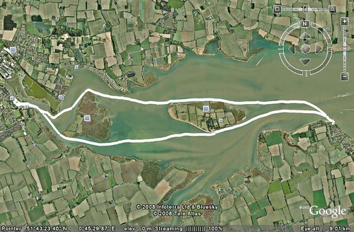
A visit to Mr Google revealed it to be a 1980 build concrete hull replica, a bit like a big Caterham seven car. It’s a 70ft gaff rigged cutter, the originals being built in the late 19th and early 20th century, being used as fast dispatch vessels for the Royal Navy. We decided to forego a lunch time drink and instead set off for the return journey slightly early a short while before the turn of tide. Just to pick things up a little as we left the protection of Northy island, wind was now against the tide for the two mile trip to Osea. At Osea we took a second short break, while, with some amusement we watched as a yacht came dangerously close to shore while seemingly struggling to tack. He was either lucky or knew his home waters very well. For the last two and a bit miles we decided to take the choppy route down the middle of the main channel where the white bits were. This led to quite a fun paddle though 3 maybe occasionally 4 ft, short and steep bouncy waves with plenty of spray and buried front ends. At the end of the trip, Sitting on the sea wall outside the Stone pub, with pint in hand. The estuary is only about a mile and a half wide at this point, most of which is fairly shallow emptying out at low tide. This leaves a maybe 2or 3 hundred metre wide channel. It was quite interesting to see a classic case of wind against tide. In the shallower and slower moving areas there were a few waves but no broken water showing. Whereas the water ebbing quite strongly against the wind in the deep water channel looked (as we well knew) to be decidedly choppy with lots of white stuff. A good enjoyable paddle, again with good company. Thanks to all who came out. On a personal note I must remember to take more photos on these outings.
Approaching Maldon quay
Written by Peter Moyse
The track.
Tuesday, September 30, 2008
Weymouth to Lulworth Cove
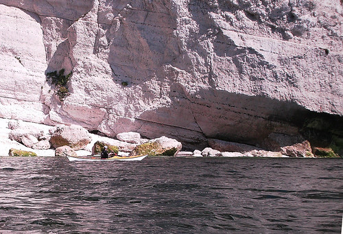
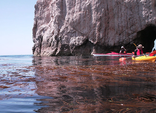
Well that was a good one. Eight of us on this trip, I will not do a role call as I’m bound to get at least one name wrong. To paddle below the cliffs of the Jurassic Dorset coast at least once a year has to be a must do paddle for anybody in our region, I’m sure that a basic knowledge of geology would have made it all the more interesting. Following yet another long drive for a good number of us we met at Bowleaze Cove car-park, which purely by chance, turned out to be a popular launching site with at least one other group turning up at the same time. We finally got on the water, regulation thirty minutes late, just as well that there are no real tides to worry about along this stretch of coast The weather was exactly as forecast force two or less with a clear sky. This all led to one of those balmy relaxed paddles, taking in the sights along the base of the cliffs and stopping for plenty of photographs. It’s not until you take a reference point, such as gulls at the cliff top that it registers how high these cliffs are. We passed under the arch at Bats head and dodged the snorkels in Man-o War bay, before arriving at Durdel Door. Durdel Door always creeps up on me just appearing as a rocky outcrop until I’m right on top of it. On to Lulworth for a relaxed lunch, at the far quieter end of the cove. On the return trip, just as forecast, the wind rose slightly to a moderate three for a short period, giving rise to a few small waves just to keep us awake. We arrived back at the launch point at 4:30pm pretty much as expected. Once more thanks for the good company of all those that attended.
Written by Peter Moyse

Below the chalk cliffs.
Written by Peter Moyse
Below the chalk cliffs.
 just to give it a bit of scale.
 through the arch at Bats Head
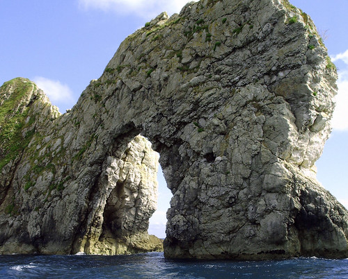 Durdle Door.
Subscribe to:
Posts (Atom)